


P U B L I C A W A R E N E S S O F F L O O D R I S K:
The role of the Environment Agency Flood Map
Prof. Mike Clark, Dr. Sally Priest & Dr. Sarah Colclough
ESRC funded research project
| 3. FLOOD MAP - BACKGROUND | ||
| | ||
|
The Environment Agency (EA) first published a national Flood Map on the internet in 2000, and an improved version was launched in 2004. The Flood Map can be reached through the EA website, for example at:
http://www.environment-agency.gov.uk/subjects/flood | ||
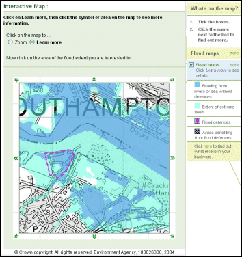
This is currently the 'most detailed and up-to-date picture of flood risk encompassing the whole of England and Wales ever produced' (quoting EA literature). People can search for flood risk likelihood based on their postcode or town name.
A Flood Map indicating the likelihood of flooding from rivers or the sea is then presented (see picture on right for an example). The location of flood defences and the areas that would benefit from them during a major flood are also included on the map. |
 | |